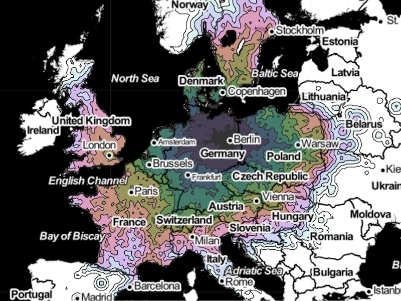
Planning a train trip around Europe? Peter Kerpedjiev, a post-doctoral fellow at Harvard Medical School, has produced a series of maps showing the distance by train between several cities around the continent, with pretty surprising results. What’s fascinating is how different cities have unexpected travel times, depending on local history and infrastructure.
The continent has some of the best rail networks in the world, so it’s little wonder that European trains carried over nine billion passengers in 2015. Europe’s train lines account for a third of the world’s total track length.
The map takes data from train travel and works on the assumption that you’re willing to walk at a rate of around five minutes per kilometer. It sounds like that would lead to some long distances by foot, but if you consider you’ll probably want to leave the station and walk around, not allowing for walking distances would probably lead to some very underwhelming maps.
Kerpedjiev tells Inverse that he originally made the map to find out which ski areas he could get to from Vienna. But after he made it, he realized it gave him a visual representation of some of Europe’s most interesting rail facts.
“It’s one thing to know that France has a high-speed rail network,” he says. “It’s another to be able to see how far it reaches and how fast it is.”
Here’s a map of Europe that shows how far each area is from Berlin — the city we’ve selected as an example. Impressively, you can get as far as London in fewer than 12 hours, a staggering 579-mile journey, thanks to the underwater Channel Tunnel connects Britain to the mainland:
You can see the tunnel’s effect when viewing the same map with London as the example city. The tunnel is an impressive feat of engineering. The project eventually ended up costing $21 billion, and it has the longest undersea tunnel section in the world, at 23.5 miles:
Norwegian capital Oslo fares less impressively. The capital of Norway, somewhat more isolated than other European capitals, is more than 22 hours away from Amsterdam despite being just 568 miles away. The Øresund Bridge that links Denmark and Sweden helps reduce times, but it’s still quite a distance:
Some maps reveal the political side of how rail has developed. Tallinn, the capital of Estonia, which until 1991 was claimed as Soviet territory, is less than a day’s journey from Moscow. The country largely uses a broader track gauge (distance between the two rails) that was popular throughout the Russian Empire:
Train travel is a fascinating way to see Europe, as each country’s network has a unique story. The European Union is even considering the idea of giving every citizen an Interrail pass for their 18th birthday. The scheme would cost an estimated €1.5 billion ($1.58 billion) and would ensure young Europeans from a variety of backgrounds get to experience the continent. Based on the maps above, recipients are in for a fascinating treat.
View the rest of the maps at emptypipes.org.
Updated 2/17 with comments from Kerpedjiev
